We stand behind every sale with a 100% Customer Satisfaction Guarantee.
If you are not completely satisfied with your purchase for any reason, return your order to us in the original packaging within 30 days of receipt and we will give you a full refund of your product costs or issue a free replacement of a damaged product in transit to you.
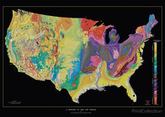
Through computer processing and enhancement, we have brought together two existing images of the lower 48 states of the United States (U.S.) into a single digital tapestry. Woven into the fabric of this new map are data from previous U.S. Geological Survey (USGS) maps that depict the topography and geology of the United States in separate formats. The resulting composite is the most detailed and accurate portrait of the U.S. land surface and the ages of its underlying rock formations yet displayed in the same image. The new map resembles traditional 3-D perspective drawings of landscapes with the addition of a fourth dimension, geologic time, which is shown in color. This union of topographic texture with the patterns defined by units of geologic time creates a visual synthesis that has escaped most prior attempts to combine shaded relief with a second characteristic shown by color, commonly height above sea level (already implicit in the shaded relief). In mutually enhancing the landscape and its underlying temporal structure, this digital tapestry outlines the geologic story of continental collision and break-up, mountain-building, river erosion and deposition, ice-cap glaciation, volcanism, and other events and processes that have shaped the region over the last 2.6 billion years.
All prints are made with the finest quality Digital Giclée printing using 12 color archival inks. We have chosen a 300gsm Rag Matt finish paper with no "Optical Brightners" to extend the life of your print.
Great care has been taken to reproduce this image for you. We stand behind the quality of your print with a 100% customer satisfaction guarantee.
Through computer processing and enhancement, we have brought together two existing images of the lower 48 states of the United States (U.S.) into a single digital tapestry. Woven into the fabric of this new map are data from previous U.S. Geological Survey (USGS) maps that depict the topography and geology of the United States in separate formats. The resulting composite is the most detailed and accurate portrait of the U.S. land surface and the ages of its underlying rock formations yet displayed in the same image. The new map resembles traditional 3-D perspective drawings of landscapes with the addition of a fourth dimension, geologic time, which is shown in color. This union of topographic texture with the patterns defined by units of geologic time creates a visual synthesis that has escaped most prior attempts to combine shaded relief with a second characteristic shown by color, commonly height above sea level (already implicit in the shaded relief). In mutually enhancing the landscape and its underlying temporal structure, this digital tapestry outlines the geologic story of continental collision and break-up, mountain-building, river erosion and deposition, ice-cap glaciation, volcanism, and other events and processes that have shaped the region over the last 2.6 billion years.
169112064PRT-008x010x000-i2720_map.2A Tapestry of Time and Terrainhttp://printcollection.com/cdn/shop/products/a-tapestry-of-time-and-terrain_large.jpeg?v=1482568651https://printcollection.com/products/a-tapestry-of-time-and-terrain16.99USDPrintCollectionInStockAll PrintsMapsNASANASA0deny